Error message

  • Warning: "continue" targeting switch is equivalent to "break". Did you mean to use "continue 2"? in include_once() (line 1389 of /Library/Server/Web/Data/Sites/Documents/jonathansblog/includes/bootstrap.inc).
  • Warning: "continue" targeting switch is equivalent to "break". Did you mean to use "continue 2"? in require_once() (line 341 of /Library/Server/Web/Data/Sites/Documents/jonathansblog/includes/module.inc).

Warning message

The service having id "facebook_widget" is missing, reactivate its module or save again the list of services.

Google Maps

Location, Location, Location - Geotagged photos on Google & Yahoo Maps using iPhone 3G

At the beginning of August I attended the Essex International Jamboree in Thorpe-le-Soken. This photograph was taken at the closing ceremony using my Apple iPhone 3G. This device has a built-in GPS receiver and is able to determine the exact position for latitude and longitude whenever required.

Usefully, location information is made available to the camera application when taking photographs with the iPhone. The latitude and longitude information is stored in the photograph's EXIF header within the file.

Using Yahoo Map's API, the EXIF data can be read and once interpreted, a location pointer can be layered on a given map.

Ultimately this means that viewing sets of photographs can be location specific. Imagine browsing your library of photographs by location. Using a map of the world I could easily find my photographs scattered in far away places including New Zealand, Thailand, Caribbean, and America.

Of course, this isn't new technology as such. Placing photographs on a map has been achievable for some years and the process of 'geotagging' images with location data is well understood by many. What the iPhone does is make geotagging very straightforward as all the location information is stored automatically at the point of taking the photograph. All that's required now is for a piece of software that can interact with the mapping API to do the rest.

With a little bit of work I was able to develop a little module that allows the location of geotagged photographs to be displayed on a map. So you kinda get a "I was 'ere" tool that shows exactly where you were standing when the photograph was taken. Unfortunately, this uses Yahoo Maps rather than the very impressive Google Maps interface - but hey, nothing is perfect.

...oh, and to see the map you'll have to view the full blog entry.

InstaMapper GPS Tracking on iPhone 3G

I'm having a lot of fun with InstaMapper's GPS Tracking application on my iPhone 3G. The client application takes live GPS data from the iPhone's position and transmits this to their servers at regular intervals. Using GPS positioning, the iPhone software can calculate the speed at which you are travelling and also the heading as a bearing.

However, it isn't until you log in to the InstaMapper GPS Tracking website and analyse the data that the iPhone has transmitted, that things become really interesting.

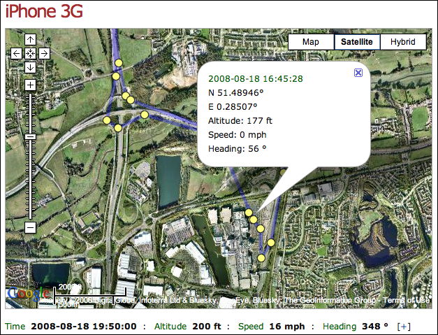
After a recent trip to the Lakeside Shopping Centre to collect a repaired MacBook, I looked at the data recorded. Journey time home was 20 mins from start to finish, travelling at an average speed of 48 miles per hour. The InstaMapper site also overlays each GPS position when data was transmitted onto a Google Map showing my entire journey to and from the Centre.

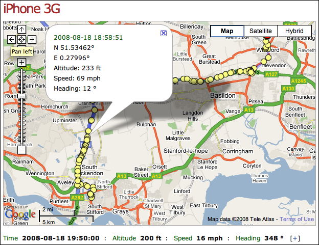
...and of course, using Google Maps as the mapping engine, it can also be viewed using the Satellite view.

I've started to cycle more regularly and next time I shall take the iPhone with me to track the route, speed and distance travelled.

Unfortunately, with Apple's policy on not permitting 3rd party applications to multi-task on the iPhone, the application only transmits data when it has been launched and is the running foreground application. This means you can't have the device constantly uploading GPS data - which is a real pity as this would then become the ideal anti-theft security system. Well, it wouldn't stop the iPhone from being stolen, but you'd be able to track the device quickly and within just a few metres. I'd love to see InstaMapper creating a variant of their tool which perhaps just uses a Unix application which runs in the background and posts GPS data - it doesn't need a GUI. Is this possible?

There are inherent dangers of having a device posting GPS data of course, not least having someone close to home knowing exactly where you are at every heartbeat. Hmmmm.  Or, as in this case, being busted for growing Cannabis plants

Subscribe to RSS - Google Maps