
The London Underground Tube Map for the Apple iPhone, iPod Touch
Categories:
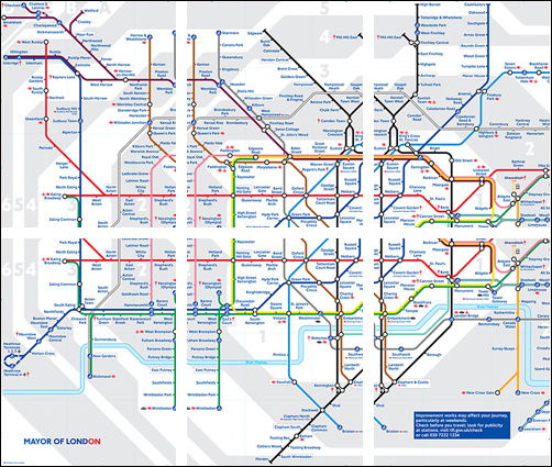
I carry a little folded up piece of paper in my wallet of the London Underground tube map to help me find my way around the Tube network. It's also helpful to have a map to refer to when there are delays and cancellations on the tube network, and that's more usual than not - or maybe it just seems that way.
I found an underground map for the Apple iPhone, which has been specifically designed for the iPhone's screen size. A single jpg image doesn't work because when the image is optimised for the iPhone, the size and quality of the image is reduced, meaning station names can't be read.
How to use and install on the Apple iPhone
- Download the underground tube network files from this site.
- Import the archive contents into iPhoto.
- Create a new album called something you can remember, such as "Underground" and drag the photos into the folder
- Set your iPhone to sync with that album via iTunes.
- Navigate to your Photos on the iPhone and the album name you created. Simply scroll between each section of the tube network map.
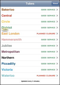
I've also installed a WebApp which shows the current status of the Underground Network.


Comments
visitor
26 February 2008 - 11:09pm
Permalink
D
Sweet, added to homescreen :)
visitor
28 February 2008 - 11:59pm
Permalink
plemeljr
If you noticed, the iPhone Underground Map I made is composed of 6 different jpgs.
Thanks for the link!
visitor
9 March 2008 - 1:23am
Permalink
chris
It would be usefull to have images of just zones 1 & 2. Just the cernter of london. As using the current images the center of london is at the bottom of the images.
visitor
22 April 2008 - 10:35am
Permalink
Phudu
fanks mun fur thiz
visitor
2 July 2008 - 10:04am
Permalink
Rob
Wicked! Thanks fella, you're a star.
visitor
28 July 2008 - 10:27am
Permalink
ben
make it an application rather than just pictures. so you can have a tube map icon on your springboard.
DO IT!.....
visitor
26 November 2008 - 4:34pm
Permalink
Angie
How? Do you know where I could find out how to make an app out of it? Or if you have the time to make one for all of us? :) :) :)
visitor
25 October 2008 - 10:54pm
Permalink
GaryC
Hi Jonathan
Please include DLR in the tube status. It would be more useful.
Thank you!
Add new comment